
This Port Elizabeth image is courtesy of Flickr. Click on the Flickr account holder below the photograph to see more.
Image from page 15 of “Battles of the nineteenth century” (1901)
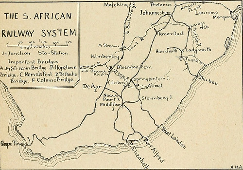
Image by Internet Archive Book Images
Identifier: battlesofninetee06forb
Title: Battles of the nineteenth century
Year: 1901 (1900s)
Authors: Forbes, Archibald, 1838-1900 Atteridge, A. Hilliard (Andrew Hilliard)
Subjects: Battles Military history, Modern
Publisher: London New York : Cassell and Company
Contributing Library: University of California Libraries
Digitizing Sponsor: Internet Archive
View Book Page: Book Viewer
About This Book: Catalog Entry
View All Images: All Images From Book
Click here to view book online to see this illustration in context in a browseable online version of this book.
Text Appearing Before Image:
the railway fromPort Elizabeth, which enters the Free State byNervals Pont Bridge on the Orange River, andthen goes north through Bloemfontein (the FreeState capital) and across the Vaal to Johannes-burg and Pretoria. A third line from the portof East London joins the Free State railwayat a junction north of Norvals Pont, and hasanother connection with the Port Elizabeth-Bloemfontein line by a cross line to Middleburgin Cape Colony, where the cross line from DeAar also comes in. Middleburg is thus thechief railway junction south of the OrangeRirer. The line east of the Basutoland moun-tain mass runs from Durban, the port of Natal,through Pietermaritzburg and the northern coaltield of the Colony, traverses the ridge at LaingsNek by a tunnel, and then runs on to Johannes-burg. It sends off a branch at Ladysmith through Van Reenens THE S.AFRICANRAILWAY SYSTEM J-Junction yiws-^ ? lmporant B>-lt>eii.sBridij5 B.Hopctown?)»-i jt^t C Not-vdsPonf D.BetWIic Mcvfek
Text Appearing After Image:
V B»-ldQe,-E.ColensoBrid3& Jl Fhe railways, following the original lines otimmigration and settlement, lie west and eastof the Basutoland mountains, in Cape Colonyand in Natal, and the British plan of campaignwas determined largely by their position. The two chief Cape railways are—(i) the linefrom Cape Town to Kimberley and BuluwaVo,which crosses the Orange River just outside theFree State frontier, and runs along the highveldt parallel to the western border of the tworepublics, through Kimberley, Vryburg, andMafeking into Rhodesia. At De Aar junction,just south of the Orange River, it sends otT a Pass in the Drakens-berg to Harrismithin the Free State.These were thelines running fromBritish territory be-fore the war. Therewas another railwaygiving access to theTransvaal from Por-tuguese territory onthe east coast. Itstarted from Lou-renco Marques onDelagoa Bay. AtKomati Poort itclimbed the easternAvail of the plateauby a boldh con-structed rackworkline, and then was carried
Note About Images
Please note that these images are extracted from scanned page images that may have been digitally enhanced for readability – coloration and appearance of these illustrations may not perfectly resemble the original work.
Submit your Port Elizabeth image here.

Port Elizabethan
Latest posts by Port Elizabethan (see all)
- Why Fewer People Are Being Convicted for Commercial Crimes - 15 May 2026
- Urgent Call for South Africa to Support and Join Global Efforts to Phase Out Fossil Fuels - 15 April 2026
- Unfenced 6 SAI Army Base Outside Makhanda Claims Another Life - 20 November 2025
- Death Toll Rises From Makhado Bus Crash - 21 October 2025
- Law Clinics Flooded as Home Affairs Blocks Asylum Seekers From the System - 15 October 2025
