
This Historical Port Elizabeth image is courtesy of Flickr. Click on the Flickr account holder below the photograph to see more.
Image from page 1015 of “The international geography” (1916)
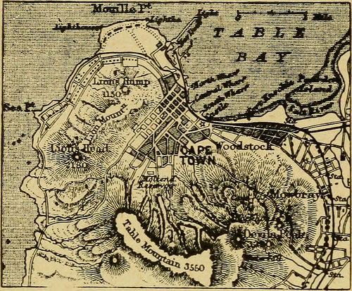
Image by Internet Archive Book Images
Identifier: internationalgeo1916mill
Title: The international geography
Year: 1916 (1910s)
Authors: Mill, Hugh Robert, 1861-1950
Subjects: Geography
Publisher: New York : D. Appleton
Contributing Library: University of Connecticut Libraries
Digitizing Sponsor: University of Connecticut Libraries
View Book Page: Book Viewer
About This Book: Catalog Entry
View All Images: All Images From Book
Click here to view book online to see this illustration in context in a browseable online version of this book.
Text Appearing Before Image:
the Gem of the Karroo. NearCape Town, a side branch runs to Malmesbury, the wheat district; and inthe north-west a small line serves the copper mines of Namaqualand(Fig. 437). Other lines, now being made, will connect the east with thewest. Much of the trade of the colony, and of the shipping at Cape Town, is,in normal times, concerned with the transport of material to the Transvaalaiid the export of gold from the mines. •Divisions and Towns.—The political divisions of Cape Colony arenot of rxmch importance as such, but the broad distinction between Eastand West is more than merely nominal. The stream of English immigra-tion, finding theWest already occupied, was diverted chiefly to the East, thuslargely altering the balance of nationahties. From time to time, indeed,there has been much agitation in the East for separation, but the feelingof cornmon interesthas up till now carried the day, and in spite of alittle naluratl jealousythe claim of Cape Town to remain the capital of the
Text Appearing After Image:
Fig. 471.—r/ie Site of Cape Town. 992 The International Geography whole country is everywhere admitted. In population, Cape Town main-tains its historical lead, being equal in this respect to the next three townstogether, namely, Kimberley, Port Elizabeth and Grahamstown. Besides being the seat of government, it Tfagoigp? jiat -1^ -i^^^ r^:i1 has the advantage of unrivalled residential charms in its suburbs ;its situation at the foot of TableMountain, flanked by the DevilsPeak on one side and the LionMountain on the other, entit-ling it to rank among the mostbeautifully placed cities in theworld. Its population is verydiversified; Dutch as well asEnglish is freely spoken amongthe European inhabitants, andbesides types of all the blackraces there are some ten thou-sand Malays, descendants of Asiatics originally imported as coolies. Kimberley, founded as a mining camp in 1870, depends for its impor-tance entirely on the diamond mines. Its site was originally of the mostunpromising kin
Note About Images
Please note that these images are extracted from scanned page images that may have been digitally enhanced for readability – coloration and appearance of these illustrations may not perfectly resemble the original work.
This image is automatically selected as it was published with this keyword/s relevant to Port Elizabeth: Historical Port Elizabeth. Please – CLICK HERE to report any ‘offensive’ images. Don’t forget to support and thank the photographer.
Submit your Port Elizabeth images here.

Port Elizabethan
Latest posts by Port Elizabethan (see all)
- Why Fewer People Are Being Convicted for Commercial Crimes - 15 May 2026
- Urgent Call for South Africa to Support and Join Global Efforts to Phase Out Fossil Fuels - 15 April 2026
- Unfenced 6 SAI Army Base Outside Makhanda Claims Another Life - 20 November 2025
- Death Toll Rises From Makhado Bus Crash - 21 October 2025
- Law Clinics Flooded as Home Affairs Blocks Asylum Seekers From the System - 15 October 2025
